
Brocken Spectre on Ill Bell
There are some days which surprise you. Some days when I wouldn’t want to be anywhere else or swap places with anyone else. Yesterday ticked all three boxes.
The surprise? It was difficult to anticipate the latter two points, when, at the beginning of our walk around Kentmere Horseshoe I took the picture of feet, making the comment that as visibility was so bad this was possibly the only clear photo I was l likely to take. How wrong was I?

The mist was not thick so there was hope, especially as the forecast was good, that it would burn off, but my senses said otherwise as we set off up Gartburn pass and then branched off up the hill towards Buck Crag.

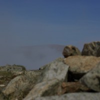
As we climbed to Yoke I glanced down to my right and realised for the first time quite how close to the edge the track was and just how steep the fall to the valley floor. Then, slowly, blue began to appear thought the mist and visibility increased. Over Yoke and on towards Ill Bell a slight breeze began to play, resulting in Mediterranean blue one second being replace by the mist filter within the space of a shutter click. Then, as if in a well rehearsed play, we rounded Ill Bell, and the curtain of mist withdrew. We were above the cloud. Inversion. The mist continued to float before us. The spotlight of sun drifting across hill tops, Kentmere reservoir and the valley floor. Creating a sense of movement as peaks and valleys were revealed and then hidden again by the moving curtain of mist.


Then, as we stood on a ridge with the sun behind, a Broken Spectre appeared. Not incredibly clear in the picture as the mist was fleeting, but the ghostly rainbow around my shadow was most definitely there. Probably the closest thing to a halo I shall ever I have.

We stopped for lunch on Froswick. The drama of mist and sunshine continued to entertain and Thornthwaite vied with the cloud to create the greatest spectacle. I found it difficult to eat as the scene was changing by the second and I wanted to capture every frame. The battle of the elements was eventually won by the sun. Once lunch was over and we had progressed as far as Thornthwaite, the sky was blue with the merest suggestion of cloud floating high above. It was a only step, or three, to High Street and now we could see that important spike of the horseshoe, where we had come from; the three peaks of Yoke, Ill Bell and Froswick.

To the North West was the Helvellyn Range and at various turns in the undulating journey to Harter Fell: Hayseswater, Blea Water and Haweswater sit deep in the northern valleys. From Harter Fell the the horseshoes concludes with Kentmere Pike and Shipman Knotts.

Though we have had rain to the point of saturation over the past few months, the dryness of the peat was striking, turning into crazy paving when a few weeks ago it was either frozen or impassibly wet.
Spring was beginning to appear even at altitude with cotton grass creating green, spiky hedgehogs. The deeper greens becoming prevalent again as we headed once more, down to the valley floor, where Kentmere village sat in the early evening sun.

Start from Kentmere Church. There is limited parking on the road but a field was open for parking, honesty box, at £3 for the day. Grid ref NY 456041 A map of our approximate route can be found here.
You need to be quite fit as the stats indicate; Total Distance 12.2 miles, Total Ascent 3700 feet, Equivalent Distance 19.7 miles
It is clear to follow from OS OL7 for most of the way, but you will need OL5 for the three steps to High Street, and if you want to name the fells and lakes which surround you.
It took us 6 hours to walk this route, have you walked it? Add your comments below (scrol down).
See more of photo frenzy in the slide show below

Receive my posts by Email or click to email
Please click the submit button and share me with the world.
Share
4 Comments
Trackbacks/Pingbacks
- The Howgills - [...] at the satellite image of Google Earth checking exactly what we were able to identify, including Kentmere, last week’s…
- Walking Troutbeck Tongue - [...] path drops to the right and down to the Ing lane. The height and grandeur of the west side…
- Capture the Colour – in Cumbria - [...] Blue [...]
- Kirkstone to Glenridding - [...] Bus timetable here, and books here. To learn more of the Kentmere Horseshoe click [...]
- High Street on New Years Day - [...] of sun on High Street here Buy Wainwright’s book [...]
- Blea Rigg and Tarn Crag from Grasmere via Easedale Tarn - […] tagged along the Kentmere Horseshoe, with a friend, who IS doing the list again and well. I am not…
Wow some awesome pictures in the slide show.
Thanks – it was an ‘Awesome’ day!
A very good account of this round or horshoe. Thanks for the parking tip as I had heard it was an issue which has kept me from the valley.
Thanks Ray. Not sure how long they keep the field open, but it did make life easy.
Alvina