
Walking The Tongue
The Troutbeck Tongue sits between the jaws of Hart Crag and the west ridge of Kentmere, by all accounts formed when its rocky core proved too much for the glaciers to shift. I looked down on the valley and The Tongue from Red Screes a few weeks ago and wondered how to get there.
This is a good walk for anyone who is not feeling very fit as it is practically flat with an easy slope up the hill, yet it gives access to some classic Lakeland views and fells. Although starting on the main road from Troutbeck over Kirkstone Pass, time on the road is negligible and, yet again, we met very few other walkers in this beautiful valley.
Just north of Limefitt Park a stony path drops to the right and down to the Ing lane. The height and grandeur of the west side of the Kentmere Horseshoe can be appreciated as the range rises sharply upwards. The visibility was much better than when I walked the range and the mist hid all trace of Trout Beck, bar in one hazy moment.

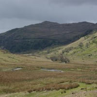
Ing lane follows the valley floor, crossings of the beck twice before reaching Troutbeck Park Farm at the tip of the Tongue. The tenacity of farmers has to be admired even today. The farm sits in splendid isolation with mountain ridges on three sides, and an erratic river just below. Difficult conditions with 21st Century technology and transport, but a couple of hundred years ago I doubt there was much pleasure in living there.
The Tongue rises up beyond the farm, with Trout Beck to the left and Hogg Gill to the right. We followed Trout Beck with the teeth of High Knotts and Hart Crag sharp to our side. Beyond Park Farm we crossed the beck for a third time on a stone bridge whose original load must have been much greater than people.

Reaching the base of The Tongue, the valley regains its full width and Threshthwaite Mouth looked an easy stroll up. Our plan was to drop down the side and return via the alternate jaw of Froswick and Ill Bell The top was shrouded in mist with little to see. On the way back we needed to cross the beck again. The heavy rain of the previous two days had swollen the flow from a ‘sole deep splash’ more ‘intimidating’ force. We could find no where to cross with less than a ‘calf deep surge’. In the end we just took off our boots, rolled up our legs and paddled!
The water was not as icy as anticipated, it is May, so enjoying the sunshine between the showers, and sitting on rocks, letting our feet dry was an unexpected pleasure. In fact my feet felt so good walking back; I decided a restorative foot wash is worth repeating.
Having negotiated the ‘river crossing’ we walked as short way up the east side ‘jaw’, to join the old Roman Road from High Street. Being Roman, it was level and straight, and a fairly easy path back down the valley. The only obstacles being white water, spectacular as it fell down the Gills, it covered the tracks and we played elaborate games of hopscotch crossing them.
No Comments
Trackbacks/Pingbacks