
Red Screes from Kirkstone Pass
After the pretty dreadful Easter weekend it did eventually stop raining and so at the first opportunity when sun was sighted, I just climbed high. One peak that had eluded me to date was Red Screes which towers over Kirstone Pass.
Just a note, we approached Kirkstone pass from Troutbeck taking a small road, Mislet Brow turning into Moorhowe road. This not only cut off a big corner, but gave the most amazing view of the Cumbrian Hills from a road I have seen. Apparently, as it is west facing, it is worth going at sunset. I am reliably informed. Take a right turn off the A591 OS4607983.

Back to the walk. My companion, Katie, had been up Red Screes before straight up from The Kirstone Pass Inn, where we parked, so we looked for an alternate route. As we just followed the OS map I am not sure there is a ‘walk in a book’ but will see if I can find one.

From the car park across the road from the Inn we took the permissive path down towards Brothers Water. The path passes by Middle Dodd and carries on passed High Hartsop Dodd and down to the lake. At the spur of High Hartsop Dodd there is a path on the ground straight up to the top. This is not marked on the map, but it is an open access area and there is a clearly defined path on the ground. From Bell Knot there is then a mapped path across the ridge to Little Hart Crag.

From here we dropped down to something which must have a correct geographical name, (please tell me if you know). An upland valley where four routes meet. North West to Dove Crag and the Fairfield range, South west down Scandale Pass, North to Caiston Glen and back to Brothers water and finally South East, our ultimate route to Red Screes. As it was such a lovely day and ‘it was there’ we took a slight detour to walk up to Middle Dodd. Another Wainwright ‘bagged’.

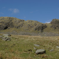
Red Screes is craggy and impressive and still had pockets of snow on the northern ridge.

The path down was not the highlight of the day. As it’s name suggests it is pretty much ‘scree’ and yes, it is red. So it was a careful descent with more watching of feet than the hills around. One thing that was a surprise was seeing a Ring Ouzel. This is a black bird about the size of a blackbird with a white ring around the breast. We did not know what it was but the RSPB’s Identifier helped and the call was very clear. Reading the breeding ground of steep sided valleys, crags and gullies, it made perfect sense that it should be there. Sods law I had the wide angle lens on my camera, and where I was perched, let alone the bird, was not the best choice to faff about.

Safely in the valley we could see black storm clouds approaching. The April showers were back.

No Comments
Trackbacks/Pingbacks