
The Howgills
Some how the Howgills had lodged in my mind as a ‘soft option’ to the Lake District hills. Well on Friday I learned better! They may not be as high, The Calf being the highest peak at 676m, but they are steep. Lots of facts and figures can be found here .
We started from the southern edge, Sedbergh, and the footpath is not a gradual ascent. It hits you straight on and up! Mercifully the views give a valid excuse to stop and look back as the dales stretched out. As height was gained, even on the dull day it was, more of the earth tipped into view until eventually, we were able to see as far west as Morecambe Bay and the Kent Estuary. Even the Arnside Viaduct was visible. I have just wasted a happy half hour looking at the satellite image of Google Earth checking exactly what we were able to identify, including Kentmere, last week’s hike.
We hadn’t climbed very far before we hit snow pockets. The rain in the valley earlier in the week had obviously hit the hills a little harder. There was not much left but it was rather grim and cold, made all the worse considering the wonderful weather of the past two weeks. No wonder the weather is a national obsession.

The Howgills are rather like the spokes of a wheel. You climb up one spoke and then from the centre have the choice of which to descend. From the top I had made the comment that the ridge down to Tebay looked rather like a camel, so I was quite pleased to read that Wainwright described The Howgills as a ‘sleeping elephant’.
The difference between this, and a horseshoe walk, I discovered, is that if you don’t descend to the very tip of the spoke, your return is as strenuous as your outward walk as you have several valleys and ridges to negotiate. One drop was steep and covered in soft turf, being in waterproofs, by this staged dried, I just sat down and slid all the way to the valley. Childish and exhilarating. May be I have found a new sport. Suffice to say all but one of our group followed.
I haven’t been able to find our exact route, but this map shows it more or less in reverse. There is a walk in this book, which looks similar

Though we took a short cut on our return from Castle Knot across to Capel Beck and then stayed above the fell intake wall.
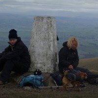
So, I did the Howgills. Winder, Arant, Calders, The Calf and White Fell. Not a ‘soft option’.
Check out my ‘store’ for books, music etc. If it’s on Amazon, you can buy it here