
Ingleborough from Clapham
I live very close to junction 36 or the M6. This is not a very salubrious address, but put another way, I live in South Lakeland, on the edge of the Kent Estuary, between the Lake District and the Yorkshire Dales. Look one way from the village and you can Kentmere and even the Langdales, on a good day. The other way and the flat top of Ingleborough waits for a walk.
Which, at last, is where this preamble is taking me. Rather than heading to the Lakes, I went east, through Kirkby Lonsdale and out to the Dales.
From the main car park in the village, we headed west through some tunnels, under a man made lake created from Clapham Beck. Long before planning permission, in the days when labour was cheap. Through the tunnel and into a characteristic Dales, wall lined track

Walls in Cummack Dale
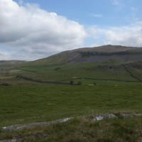
Just north of Austwick we took a left turn and moved in to a landscape which, on the map is littered with the black and white squares of rock outcrops.
These must be so much more fun to draw than roads and railways. Anyway , from the ground they are pretty obvious and I caught my first sighing of ‘destination Ingleborough’, with its distinctive flat cap.

Perfect place for a flapjack stop, half way up Crummack Dale and the ancient Wash Dub Field where sheep dipping used to take place.

Wash Dub Field and Clapper Bridge
Over the ridge beyond Moughton Scar, you’ll find yourself surrounded by vast limestone pavements and view the tripartite peaks partner, Pen-y-ghent. I was grateful the conditions were a little better than my hike over that hill.

The pores of limestone and numerous potholes meant the whole of the walk was pretty much dry underfoot. Not a spot of soggy sphagnum to be seen.

Moughton Scar
Once up on the Yorkshire flat cap Whernside appeared. That was going to have to wait for another day. Our route down was south down Little Ingleborough and passed a pot hole I had heard of, Gaping Gill. There was a small village of tents surrounding the Gill and the stream had been almost blocked and diverted away from the Gill. Apparently Bradford caving club was exploring and the following week it would be possible for the public to go down into the cave for a fee. Secretly, I was pleased it was not open. I would much rather remain above ground.

Trow Gill
Trow Gill was a surprising exit from the moorland and the only, slight, scramble of the day.
The rest is a positive stroll in the park. Pass by Ingleborough Caves, a detour if you are so inclined. Just beyond the caves there were a pair of grey wagtails cavorting. I don’t think I have ever seen them before and they were exotically incongruous for a Yorkshire Dale. Incredibly long, wispy tails. No picture. Wrong lens, and they were moving too fast. Check the RSPB.

The Lake – Ingleborough Hall
Finally, when I thought there was nothing much else to see, the path goes by the lake over the tunnels, with imported rhododendrons and artificial landscapes, culminating in a waterfall to the village.
So, that’s two of the three Yorkshire Peaks – anyone fancy a hike up Whernside?
Although this walk started from Clapham it could be a railway walk from Horton in Ribblesdale.

Route details here.
Map