
Bleaberry Fell
Sometimes there has to be a ‘plan B’ but thankfully, it does not always need to be used. With the possibility of low cloud, I had a couple of routes planned from Armboth car park on the west side of Thirlmere.
We set off westwards up the side of Cockrigg Crags on the footpath to Watendlath. It is pretty steep way up from the shore to above 400m. Thirlmere was quickly left behind as we walked up the unusual scattering of large boulders which had detached themselves from the Crags.

Therlmere
An indication, which we did not pick up, of what was to come, was the heavy spate in the stream by the side of us and a second stream under our feet. Appreciative as we were of ‘fixed fell’ foot path, it resembled a shallow waterfall much of the way up the gill.

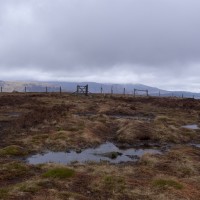
Armboth Fell andHelvellyn Range
As the cloud was considerately remaining aloft, we carried on up above the tree line, ‘plan B’ was to turn right and keep low. The inclination became more gradual as we made our way onto open fell and we became very aware of what a perfect location for a reservoir Thirlmere is. The fells between it and Derwent are a perfect watershed. A sphagnum sponge. At times we were walking through, rather than on, a soggy, green sago soup. Hi technology may make for waterproof boots but after being over the tops a few times, no I wasn’t wearing gaiters, I had to rely on the wetsuit effect to keep my feet warm.

High Tove
High Tove was our first achievement and gave us a bit of dry space to perch on to while we drank coffee and ate the inevitable flapjacks. A detour is worth taking a little way further towards Watendlath just to take a look over Rosthwaite and Sergeant’s Crag. Back on intended track we squelched our way towards High Seat. For once a few moor contour lines would have been very welcome. Looking now at the map, the area is called the Pewits, more a case of ‘phew, we’re over it’.

High Seat has a trig point rather than just a pile of stones and the grey line remained just high enough for us to see south westish to Borrowdale and north over Derwent, Keswick and Bassenthwaite. High Seat is an optional point for dropping back to Thirlmere, but as we could see it, and it really didn’t look that far, we thought we may as well ‘bag another Wainwright’ and continued to Bleaberry Fell. We made it just before the cloud. It was tempting to sit in the shelter and simply enjoy the lakes and the sight of Skidaw and Blencathra, but the cloud was probably about to hide them and common sense, for once, prevailed and we retraced our steps towards High Seat and then dropped down over the open fell, just managing to keep below the cloud.

Derwent and Bassenthwaite from Beaberry Tarn
Don’t expect to find a path to follow. There isn’t one. The reason for retracing back to High Seat is to avoid having to negotiate, Goat, Iron or Castle Crag. South of them the descent is a little more forgiving and we did eventually end on a vehicle track which led us to the edge of the fell and forestry plantation. It wasn’t that much drier down here and so we had a quick stop for lunch at a very uninspiring picnic point before heading north again.

Blencathra
For once a forestry trail was good to follow. We had had sufficient unspoilt fell for one day and were content to keep our feet out of the water and find our way down under Castle Crag. There is the option of quickly going up the ‘ancient monument of Castle Crag’ Raven Crag and/or The Benn, to enjoy a view over and along Thirlmere. Unfortunately Anne had an unfortunate slip and consequential dip in a rather acrid bog, exacerbated by forestry work. I can only admire her tenacity as wet and somewhat aromatic she made it up Benn, picked as we had read it afforded the best view. But one was enough. We were both quite happy to head down through the woodland directly down the hill and follow that tarmac ribbon back to the car.

Thirlmere from Benn
Route ideas from Cicerone North Lakeland walks, with a contribution from Go4walk C318. The map OL4.
No Comments
Trackbacks/Pingbacks