
Great Gable from Seathwaite
We shouldn’t gloat, but we do, especially when the wet windy rainy north west has the best weather in the UK. Just a perfect day for putting on boots and walking one of the landmark fells.
One of the great things about the Lakeland fells is the lovely round topography. Although there may not be as many peaks or mountains as other countries, there are so many different ways to get up. Looking at the OS Map there is a positive web of green lines indicating rights of way over Great Gable. Six cross the Westmorland Cairn spreading to all corners of the compass. The grades of walk vary from the strenuous uphill walk from Seathwaite to the more challenging route up Kern Knotts and Raven Crag.
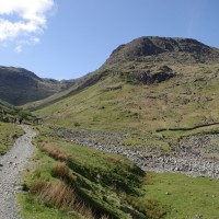
If you don’t want to walk all the way from Seatoller you will need an early start. Even arriving at 9.30am the parking in the valley was filling fast but as this is also a start point for Scafell, Glaramara and more, walkers and climbers soon dissolve into the hills. Approaching Stockley Bridge the fells rise steeply in front and to each side. Wonderful visibility gave the impression of the hills being cardboard cut outs pasted on the worlds blue screen. The valley walk to Styhead Tarn is an easy warm up but the Stretcher Box is a sharp reminder that the fells hide danger even on this day of benign serenity, and yet again we were to witness the air ambulance in action later in the day.

A little beyond the tarn the uphill begins. A choice of fells there is, but unless you turn around, upwards you go. For Great Gable, swing right. A clear trail leads up, quickly and steeply. Green grass changes to loose scree, with the iron giving painting a red hue to much of the surrounding rock. It is was not a silent climb, the scree ‘clinked’ as we walked, sounding much like a high rise beach walk. Looking back there were distinct bands of colour across the sharp fall. Seathwaite only just remained in view but the surrounding hills were creeping into view over the tops of Borrowdale fells.
The reward of careful footwork crossing the last few metres of loose rock is more than worth it. The Westmorland Cairn provides resting place and the dome is wide enough to accommodate the many walkers who had congregated there. No one was in a hurry to leave this particular ‘top of the world’.
Scafell Pike was so clear an outstretched hand would surely touch it? Deep fissures splitting the hills apart where they have been pushed just a little too far. A little beyond the Irish Sea wrapped hazily round the Isle of Man. Panning round right and west Eskdale, Wast water and Ennerdale emphasised our remoteness with their long isolated valley entrances to the fell. Haystacks looked comparatively low, may be someone had sliced off the top just to open the view to the Solway Firth.

Before leaving the summit be sure to take a quick look at least, at the commemorative plaque to climbers who gave their lives in the wars.
Once up on the hill, as previously, there are other peaks to step on. Following the line of cairns we dropped down to the cross roads of Windy Gap and up again to Green Gable. Yes it is green on top, relatively speaking! A little closer to Scotland the Solway was yet more vivid and Buttermere slipped in before Crummock water. From Green Gable there was little effort required to cross to Brandreth and Grey Knotts. Nothing to detract from the stillness, the sparkling tarns and undulating glacial landscape, unless, of course, you fall in a peat bog!

Descending from Grey Knotts wits had to be engaged once more as the terrain becomes more craggy. As the car was at Seathwaite we left the main trail to Honister and cut south west below Raven Crag, crossing Sourmilk Gill, to join Gillercomb and the trail which runs direct from Green Gabel. Though the Seathwaite Slabs proved to be an irresistible distraction, with their plentiful handholds.
The last descent follows the Gill and waterfall, but it so closely follows the river course the contours were just too much for four small legs.
Unlike Torver Fell this popular route is easy to follow on a clear day but the safety net map required is OS4. Great Gable and the whole route we took is on the South Sheet, but it is worth taking along OL6 just to identify the rest of the Cumbrian round.
Remember follow the link from my page to buy your maps and books. To see the slide show in action click (too many wonderful views to add to the post) and finally, like me on your facebook page, and now I am even on Twitter.
One Comment
Trackbacks/Pingbacks
- Scafell Pike from Wasdale - [...] clear, with not a cloud in sight as we set off up the valley towards Sty head with Kirk…
Great blog! Love the photos… I have fallen in many peat bogs sadly…not glamourous! 😉