
Walking Wheels
I love the wheel topography of Cumbria. Such a small place but so many different ways to get to the hub. Even if you tick off all your Wainwrights, Birketts or whatever list you follow, there will inevitably be another side to arrive.
Causey Pike had led me to Coledale Hause at the end of last year, returning by Crag Hill and Outerside. This time I went up from Crummock Water, parking at Lanthwaite Green.
There are a couple of routes up to Whiteside from here. Take the one up Whin Ben if you want to walk. We thought that a direct route marked on the map would be a quicker option. It was direct. Directly up.

I think we possibly missed the route a bit. Or it had not been used for 50 years. It was a scramble over heather and bilberry bushes, or scree. At least there was something soft to sit on when we paused for a break.

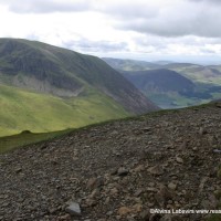
Reaching Whiteside and able to take a more vertical stance, all was worth while. The grey ridge to Hopegill Head wiggles ahead with Ladyside’s alternative route leading to Whinlatter.

To Hopegill Head and Grisdale Pike is the next spoke to fan north, but we dropped down the scree of Sandhill and south to the Hause. Here the gloves came out. It may be August but the wind manages to pull cold air over the dip, freeze fingers and rattle ears very effectively.

Suddenly the people traffic arrived. Walkers with differing agendas dropped in from Borrowdale, Whinlatter and Crummock Water. Quickly to disappear again on their respective circuits.

More pieces of the topographical jigsaw were put in to place as I admired Sail and enthused over last winter’s walk.

We made a diversion to Grasmoor before following the bulge up again to Wandope. It was becoming a bit of a roller coaster walk. Whiteless Pike is an impressive looking ridge but easy to walk along. It struck me looking back how gloomy Grasmoor looked.

No grass to be seen, just covered in heather and scree. Currently looking dark and harsh. In contrast the valley on the other side of the ridge was lush and green. No doubt due to weather, but it was it named for the same reason as Greenland, or has it just been grazed and walked into oblivion?

One last challenge. Rannderdale Knotts.

It looks rather insignificant from Grasmoor, 500m below, but as the drop is almost to Crummock Water shoreline, there is a temptation not to bother. The way up was fine but we dropped down to the car park on the edge of the lake via a staircase, and though a necessity, they play havoc with knees!

So here is the map, sats and download here

All described in detail by Mark Richards Great Mountain Days in the Lake District
But you will find it it equally well from the map.
No Comments
Trackbacks/Pingbacks