
The Limestone Link
I walk part of the Limestone Link on most days but I had, until Friday, never walked all of it. Farleton Knott and Hutton Roof Crags are regular stomping grounds, and anywhere between them and the western end to Arnside. Most of this part has featured in my blog. But not the start from Kirkby Lonsdale.
So on a wet grey Saturday morning, after leaving one car in Arnside, the other was parked up at Devils Bridge. Conveniently near a bacon buttie van if you miss breakfast and the parking is free all day.
There is no big dramatic sign, or even a small non descript one saying ‘go this way to Arnside’ and it took us a while to figure that the small blue arrows were not bridleway routes for agile ponies who could climb stiles and negotiate kissing gates, but rather route markers. Just after Biggins village there was a distinct lack of any markers, blue or yellow, and the only finger post pointed in an obscure direction which didn’t correspond at all to the route.

Hutton Roof
We found the first part of the walk from Kirkby to Hutton Roof Crags a little uninspiring. But then we could not see a lot, The Bald Hiker had a much better day. There was also, bar the field walls, a distinct lack of limestone.
")
Holme Park Fell
Hutton Roof Crags eventually appeared through the gloom and now being, on familiar territory, we were able to ditch the map, walk over the hill and imagine what it looks like on a clear day when the Lakes, Dales, Howgills and Morecambe Bay provide a visual feast. Instead we had a few miserable sheep. Ironically, once on familiar ground the signage became much better and there was a post pointing the way.

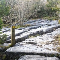
Farleton Knot follows and here the Limestone pavements, clints and grykes give meaning to the name. Sun sets are fantastic from the Knott and again, memory was a useful way of escape from our now dripping clothes and soggy feet. Unfortunately there is no escaping a rather dismal 15 minutes of walk along the A6070 towards Holme village. The only way to continue the link, is by either a road under the M6 at one end of the village, or over at the other. Take the northern route under and you can then drop on to the Lancaster canal for a short walk into the village before heading west again.

Holme Canal
For us, thankfully, this was chance to dry off a bit, have a hot cup of tea and eat lunch sat at my kitchen table. Looking out of the window we could hardly believe it when the raindrops took on a bit of glint and then stopped. The afternoon was looking more promising and gave us the inspiration to put out boots back on. It was becoming rather too comfortable.

For those who walk this route in summer be warned. The other side of Holme village there is a sign warning of aggressive cows. Take heed. They are aggressive. We only had sheep, but if you see cows with calves you would be advised to turn right along the road and then another left, which will bring you to Pye’s bridge Farm. This is a great shame as it means missing out a small wetland area with many ground nesting birds and waterfowl.

Through woods from Hale
From Pye’s Bridge you can follow the small road to Hale, or do as we did, and try to head for the A6 via a footpath. Unfortunately there was a lot of new fencing and we managed to totally miss the route and almost end up a someone’s garden, accessing the A6 by a cumbersome clamber of a locked gate.

Marble Quarry
The next section, from Hale, I think, is the most wonderful and pretty limestone area, the Marble Quarry. Here trees, and way markers, sprout out of rock in total defiance. The pavement is as flat as if it had been rolled into a natural jigsaw. Add to this the low afternoon sunshine, blue sky and catkins and we decided it really was rather a good place to live.

Slightly further on and you will find yourself at the top of the natural steps of Fairy Steps. Part of an old coffin trail. Its quite tricky to negotiate them with a backpack on so I am not sure how coffins were pushed up or down. The top of the steps is the last view point as from here the route is all down hill. Through more woodland at first, to Hazelslack, and eventually out on the floodplain of the estuary and Arnside.

Fairy Steps

Arnside
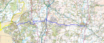
The route is 19k and easy to do in a day with a car at each end. Kirkby does not have a brilliant bus service but Arnside does have a rail station.
Better weather photos here and here .
No Comments
Trackbacks/Pingbacks