
Knock Murton
The intention was to tick off at least four off the Birkett list, this time from the far west of Cumbria, clinging to the Lake District before it falls off to what’s left of the industrial coast and the Irish Sea. But short days, irritated farmers, day-glow jackets along with inappropriate way markers were to conspire against us.
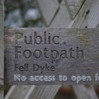
Park at Lamplugh Church, NY 089 208, and you will find an inviting stile with a path heading towards the first hill, Owson Fell. Unfortunately the right of way does not quite go ‘all the way’ to the access land and though I have seen several blogs saying ‘just ignore’ the unfriendly signs, they really are impossible to miss and I would think the land owner is well ‘issed off’ by those that do. The fact that I was also fairly unmissable in my new bright green jacket meant I could hardly sneak across the rather open space.

So, not being one to challenge authority, I opted to stay on the right off way and follow a path south ish to Fell dyke. Once there, it was a case of using the OS map and seeing where we could go and what we could see. There was a marked right of way up to Cogra Moss, pointing hill wards, so we heading up only to be a little thwarted by MAFF (obviously old) way mark arrows which pointed away from the right of way shown on the OS map, around a plantation. Being good citizens we stupidly followed them.
By now, having adjusted plans to go up Knock Murton, and just see what followed. I became unimpressed by Birkett Bagging. The underfoot going was squelchy and rough as well as being pretty steep. Advantage to the lack of path, though, was a distinct lack of other people. Can’t have everything.
On reaching the top I was appeased, where there was not only a well built shelter, but the Lake District hills

proper, unfolding west with Ennerdale Water to the south and over the Solway, Scotland. The next challenge was getting down, the other side. It was just a tad steep. Would have been far happier with skis on. Instead just slipped and slid down the peat track before deciding that negotiation of the heather roots was a slightly safer option.

The acute angle continued in the plantation, where larch branches proved unreliable handrails. The route redemption being the wonderful air moss and old man’s beard. Such an amazing colour!

Trees negotiated, it was an easy return by Cogra Moss, but at least the effort had ‘bagged one Birkett’. Not that that really bothered me, I just wanted to go for a walk!
Though I am sure there are some of you not quite as wussy as myself when faced with ‘no access’ signs, our outing did make clear the way to get to the other Birketts on Lamplugh Fell and north to Loweswater. Park at the car park at Fell End, NY 085 198. Follow the track, ignoring the footpath arrows, up to Cogra Moss and then use the forestry track to negotiate a way through the plantation northwards. I have attempted to plot it here. Will tell you when it has been tested.

More pictures from the day here.
Click below for Bill’s Book.
I am the same with signs like that – had to take a detour after a really long walk ending on Souther Fell with the Mill Inn at Mungrisdale almost in touching distance but signs saying “private land”, “no footpath” etc. Took the detour for a very tired extra 20 minutes!
Glad I’m not the only one… we had to negotiate a stream in full spate too. Not good for a dog with short legs. She did get a lift over on the way back.
Tanya, that land isn’t open fell land but is a farmers field. As such I can understand that particular sign. This forest is publicly owned, it needs a check with the parish council or Copeland.
The issue will come down to whether the whole of the forest is ‘open access land’. By this article it appears to be a publicly owned forest. The right of way seems to end as the path leaves the lake and goes through the forest. I would check up with an environment officer at Copeland Council as to whether you have full access. I believe the signs will be up as a safety issue only, when the forrest is being worked.
It is difficult to tell from the OS map. The signs were just after the Church at Lamplugh. Probably only a few hundred yards, but very clear that walkers were not welcome. Round the moss was very popular and we met several people walking on the forest tracks.
I did more or less this walk on Saturday and found it really interesting and easy to navigate. As with all Birkitts they are regularly walked so theres always some sort of path even when as on this circuit Bill says there aren’t but then again it was first published back in 1994. Technically there is no access from the moss side footpath to the woodland and from the woodland to High Hows top. Without knowing of any local landowner/user agreements you cannot be sure if you are in effect trespassing or not but at least there are no signs stating you cannot access the woodland and theres plenty of evidence to show the path is well walked. As for the access from Lamplugh to Owson Fell there is no argument. The field is out of access without a right of way and therefore there is no access therefore the land owner has every right to deter passage. The access land and open access woodland is clearly marked on the OS map.
Glad you managed to try it out.