
Solitude
It’s August. I think.
Visitors have flocked to the Lake District despite the unseasonably ‘dreich’ weather.
Pummelling rain showers can not be avoided but crowds of visitors can be.
Most people, myself usually included head for the picturesque central fells or dash up ‘north’ via the M or A6.
Passing the rounded and empty Shap fells without so much as a second glance.
In a bid to avoid the much loved tourists I decided not to go quite so far from home and visit these much maligned fells just inside the Park with the boundary wrapped around their edges.
Wainwright describes the route with no alacrity. Read his description and you may not bother to go at all. “… It is a long slog over Grassy Prairies…. not enriching to the eyes or the mind..”
It’s easy to pass the unmarked side road (NY545 013) as we did. Whiteside pike is the first bit of hill and there is a bit of flat, dodging the A6 on small roads and bridle ways before eventually reaching a sheep run to the fell.

Up to Whiteside
Whiteside, the first and last remotely craggy top, loitering ahead.

Whiteside
Inserted in the neatly built cairn, a parish millennium memorial.

Parish inscription
A faint track wound over to Todd Fell, the next on the list. The journey over rough grass, bracken and sphagnum moss was to typify the day.

July?? It was
One of the rare places there was any proof of previous walkers. For the most part we sploshed through peat bog or carefully guided our ankles through tussocks. Service of Fix the Fells were not required. Fells were managing quite well left well alone.

Each round top had a stone. Some quite distinct and others not more than a flat stone lucking amongst the reedy gold.
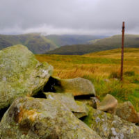
Despite pummelling rain drops the clouds remained sufficiently high to reveal the rolling hills over to Kentmere, and as far as Morecambe Bay in the other direction.

Kentmere view
Hill tops are obvious boundaries and for much of the route the fence provides a handrail to the top of the horseshoe. Round the Bannisdale watershed.

Top of the horseshoe
Eventually, almost at the end, the fickle grey broke into white interspersed with welcome blue.

And the route

very beautiful